
Troy Berkey
University of South Florida
Assessing Lava Tube Characteristics and Geometries Using Gravity and Magnetic Methods
Lava tubes are a typical constructional feature found in distributed volcanic fields and are a distinct characteristic of basalt flow fields on Earth, the Moon, and other planetary bodies. These volcanic structures offer a wide variety of benefits for future lunar exploration. As scientific targets, they host a wealth of information about the characteristics of lava flows and their interior structure and contain untouched lava, which provides vital information for understanding how lava flows change as they propagate over vast distances and offer insight into the evolution of these planetary and lunar bodies. These cave-like structures also serve a fundamental function in advancing the exploration of the lunar surface, as they can contain water (ice) and other resources and serve as possible shelter sites for future explorers due to their protective nature. However, finding these structures and assessing their viability to facilitate these functions is not an easy task.
Magnetic and gravity surveys are one way to assess these structures. These survey types show subsurface anomalies (or differences) from variations in the rocks' magnetic field and density. In my research, I use modeling techniques, exploiting these variations, to identify tube structures and characterize their geometries (height, width, and depth below the surface). I also employ LiDAR data collected by other researchers in the GEODES group to hone these models. In other words, these data essentially provide a 3D map of the existing tube geometry, which helps to reduce the ambiguity associated with the magnetic and gravity data. To serve as possible future habitats, the tubes must be large enough and provide sufficient shielding from solar radiation to preserve resources and protect humans. However, factors like changes in the lava density, magnetic intensity within lava flows, their size, and how deep the lava tubes are influence these anomalies and affect model results. To accurately estimate the geometry of lava tubes, it is vital to characterize how these factors affect the anomalies observed in the collected data. My research for the GEODES project primarily aims to understand how lava tube anomalies vary when they are entirely drained, partially drained, or not drained, how compositional changes alter the anomaly signatures, and how these anomalies change (or attenuate) with depth using magnetic data collected over Sentinel Cave in Lava Beds National Monument (LBNM) and magnetic and gravity data collected over Lava River Cave in the San Francisco Volcanic Field (SFVF).
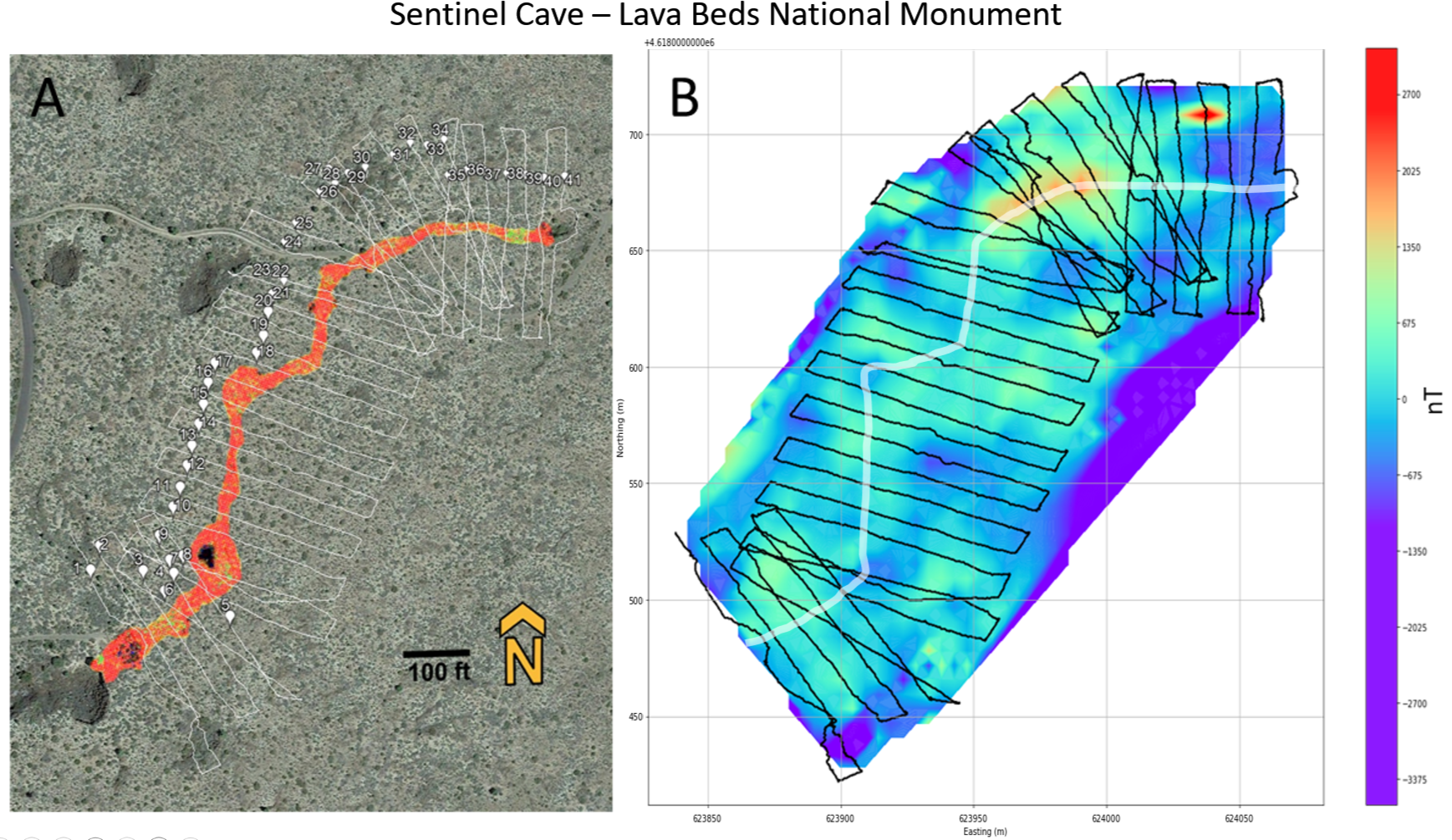
A. Google Earth map showing the magnetic survey performed over Sentinel Cave, a lava tube in LBNM, during the GEODES 2022 LBNM field expedition. Geolocated LiDAR (orange) highlights the tube extent through the field area. B. A heat map showing the magnetic anomalies observed in the study area. The white line shows the approximate location of the lava tube. Notice the tube is not well imaged due to changes in the tube dimensions, infilling, and depth. Variations in the intensities of the magnetic anomalies associated with the tube are also observed and are especially noticeable in the NW section of the survey (orange-red anomalies).