
Mariam Naseem
University of Maryland
Characterizing The Beaufort Sea Ice Using Ice Penetrating Radar: An Analog For Icy Ocean Worlds
Multiple icy moons in the outer solar system appear to host briny subsurface liquid water oceans beneath kilometers of ice. Future missions to these icy satellites like Europa Clipper, will study the surface and near-surface structures using remote sensing techniques including radar to infer geological processes happening in the interior [1]. We characterized the radar signature of first-year and multi-year sea ice in the Beaufort Sea, Arctic Ocean using ground penetrating radar (GPR). A current challenge is detection of the ice-ocean interface using GPR as the briny seawater strongly attenuates radar waves [2]. Our investigation using GPR in this analog environment will be informative for future radar analyses of icy ocean worlds like Europa and Enceladus whose surfaces are derived from the freezing of briny cryomagmas or exposed ocean [3].
To characterize the radar signature of sea ice, we conducted surveys with four GSSI antennas ranging from 400 MHz to 2600 MHz in frequency on an ice floe in the Beaufort Sea. Our field site (Ice Floe Victory) was located at Latitude 72 51.07 N, Longitude 143 40.59 W ~178 NM N/NE of Prudhoe Bay, Alaska in the Beaufort Sea, Arctic Ocean. The analysis was conducted over the course of two days on March 8 and March 9, 2023, with both multi-year and first-year ice co-located on Victory.
The GPR scans reveal differences in the radar signature of multi-year vs. first-year ice. Fig. 1 is a 10m traverse taken at 400 MHz on a section of multi-year ice with ~50 cm of snow cover. At this frequency, GPR readily detects the snow-ice interface between ~5 and 10 ns. The ice-ocean interface is not identifiable in this radargram. Multiple diffractions are seen at ~10-25 ns. We interpret these to be sourced from ridges generated by adjacent blocks of multi-year ice. Understanding how the depth and internal layering of sea ice varies spatially may shed light on accretional processes or underlying heterogeneities that formed the ice. This analog terrestrial analysis can inform future missions to icy ocean worlds aiming to study surface observables and near-surface ice structure.
References: [1] Heggy et al. (2017). Icarus. 285, 237-251. [2] Holt et al. (2009).Cold Reg. Sci. and Tech. 55(1),33-46. [3] Souček et al. (2023). JGR: Planets, 128(2), e2022JE007626.
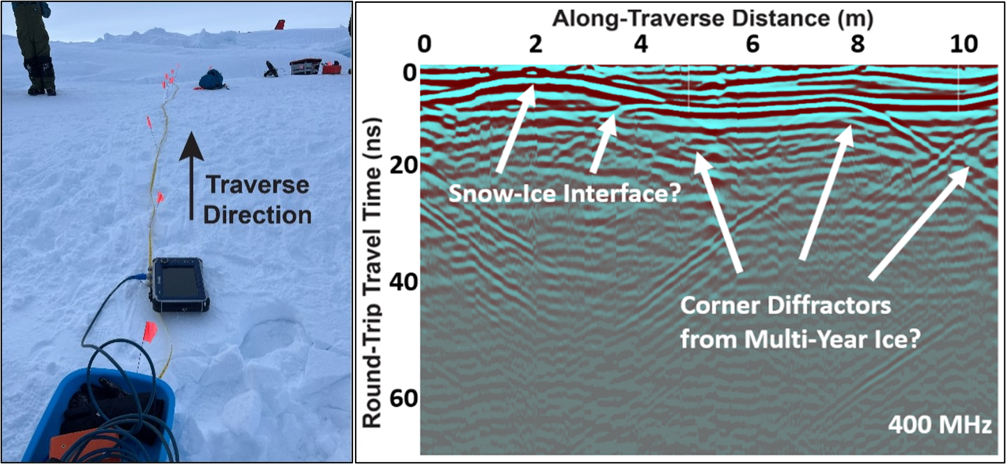
Figure 1. Ice Penetrating Radargram on Multi-Year Sea Ice. 400 MHz radar traverse (10 m line) showing possible snow-ice interface and corner diffractions from multi-year ice.